EH Bellman
Location, data and EH. A better way forward.
EH Bellman - December.10.2020
Building a Community Wide Onsite Wastewater System Inventory
Developing a community-wide, location-based inventory of onsite wastewater systems has been on the forefront of our objectives and several of our clients. In our initial post here, we mentioned a pilot project Converting Paper Site Plans with Bay County, Michigan, where we mapped onsite wastewater systems, and well water in two townships. The pilot project eventually led to mapping the entire county, where we used scanned permits (PDF) and at times, paper permits, to map onsite wastewater systems and wells, and enter information about both.
We recently completed the project, having reviewed, mapped and entered data for more than 12,000 onsite systems across Bay County. In this post we will review some of the project summary information and look at what is next.
Mapping Summary
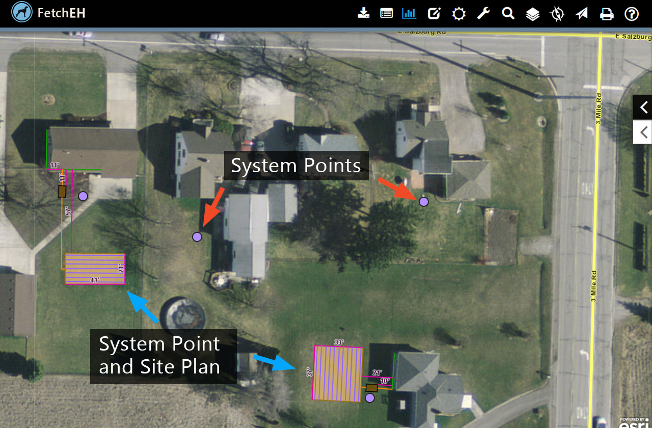
The project started in earnest in late 2018 with the final QA/QC and cleanup routines being completed in September of 2020. In that time, we mapped and entered data for 12,265 onsite systems and 4,443 wells. Mapping onsite systems included mapping a System point for every permit, and where possible, mapping the complete site plan.
Mapping complete site plans was done when information on the permit’s site plan included measurements to each component (septic tank, disposal area, well, etc.), or where we could interpret a component(s) using aerial imagery. Of the 12,265 onsite systems mapped, we were able to map complete site plans for 4,786, while the remaining 7,479 were represented on the map using only a System point. Note that in both mapping scenarios, information about the permit and components was also entered when available.
Site Plan Detail
There were also 2,072 scanned permits or paper permits that we were unable to map. These permits did not have an address or other information, such as a general location sketch, that we could use to match the permit to its true location. It is important to note that many of these permits only provided a proposed system with no final, so it is not certain that they were ever installed. The large majority of these permits were also more than 40 years old, so it is also possible that other permit documentation, such as a replacement tank/disposal area were mapped.
As expected, many permits did not have all of the information present. When we looked at age of the onsite system for example, there were 592 where the age could not be determined. There was also information missing for other key aspects, such as the size and type of the septic tank and disposal area. This missing information, along with properties with no permit on record, define the gaps in the inventory that will ultimately require field visits to learn more.
Want to learn more about the project? Visit the Bay County project page here Bay County Special Project
What's Next
The result of the project is a comprehensive, digital, location based inventory of septic systems and wells that can be explored using an interactive map, filters, reports and visualizations. Bay County will use the inventory to improve access to onsite wastewater and well water information, enhance workflows and use data to understand the inventory and align resources to mitigate ongoing or potential issues. These are all positive benefits that will ultimately lead to improved public health and environmental outcomes.
Since completing the project, Bay County has continued to pursue grant funding with a focus on identifying and upgrading failing or comprised onsite systems. In this instance, the inventory will be used to identify and group onsite systems based on some variable(s), such as age, type, size and other relevant metrics. The inventory and FetchEH will also provide options to track replacements and monitor the long-term impact to both the inventory status and the community.
So while it is still early in the post project period, there have been many benefits of building a location based inventory. Many of the early benefits are derived from simply improving access to information, site plans and seeing the inventory. Early benefits have also included the ability to ask questions about the inventory, see the results visually and generate reports that compliment the map output. As Bay County continues to work with the inventory and gain familiarity with the Insight tools in FetchEH, we will provide additional updates regarding benefits and use cases.
More Posts